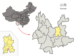
Geographical Location
There are many mountains in the southeast and northeast of Chenggong District.It borders Dianchi Lake in the west and Yangzong Lake in the east,and the east is higher than west.The altitude of Chenggong District is about 1775--2820 meters.The highest peak of the territory is Liang Wang Mountain of an elevation of 2820 meters.
Introduction
Chenggong District is under the jurisdiction of Kunming City, Yunnan Province.The total area of Chenggong District is 461 square kilometers.Chenggong District derives its name from the Yi nationality.In 2012, the total population is 350,000 in Chenggong District. Chenggong is a famous flower and vegetable production base in China,which is known as " the first flowers county in China".
Administrative Division
Chenggong District administers 10 streets:Longcheng Street(龙城街道),Luoyang Street(洛羊街道),Dounan Street(斗南街道),Wujiaying Street(吴家营街道),Luolong Street(洛龙街道),Wulong Street(乌龙街道),Yuhua Street(雨花街道),Dayu Street(大渔街道),Majinpu Street(马金铺街道),Qidian Street(七甸街道).
Ethnic Groups
There are Yi,Hani,Hui,Bai,Zhuang,Dai,Miao,Lisu and other minorities in Xishan District.
Chenggong District in Kunming City
 Location of Chenggong District (pink) and Kunming prefecture (yellow) within Yunnan province of China | |
| Country | China |
|---|---|
| Province | Yunnan |
| Prefecture | Kunming |
| Established | 1956 |
| Area | |
| • Total | 461 km2 (178 sq mi) |
| Population (2012) | |
| • Total | 350,000 |
| • Density | 760/km2 (2,000/sq mi) |
| Postal code | 650500 |
| Area code(s) | 0871 |
| Website | http://www.yncg.gov.cn/ |
You will only receive emails that you permitted upon submission and your email address will never be shared with any third parties without your express permission.
