Geographical Location
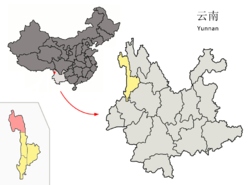
Gongshan county occupies the northmost part of Nujiang Prefecture, and in latitude has a range of 27°29’----28°23’N and in longitude has a range of 98°08’----98°56’E, covering an area of 4,506 square kilometers, bordering the Tibet Autonomous Region to the north and Burma to the west. The national boundary with Burma is 172.008 kilometers and the provincial boundary of Yunnan-Tibet is 135 kilometers. It is located in the central part of the Hengduan Mountains, and contains the valleys of the Salween, Mekong, and Irrawaddy.
Introduction
Gongshan Derung and Nu Autonomous County (贡山独龙族怒族自治县) is located in Nujiang Lisu Autonomous Prefecture, Yunnan province, China. Gongshan is a small county in Northest of Yunnan Province. Gongshan is a small charming county with deep valleys and steep, overlapping and magnificent Mountains and snow peaks.It has an area of 4,506 square kilometres and a population of 35,910 as 2012 census.
Administrative Division
Fugong county’s jurisdiction is over 1 town, 4 townships:Cikai town(茨开镇), Bingzhongluo township(丙中洛乡), Pengda township(捧打乡), Puladi township(普拉底乡), Dulongjiang township(独龙江乡).
Ethnic Groups
Gongshan Derung and Nu Autonomous County occupies by Dulong, Yi, Bai, Dai, Zhuang, Miao, Hui, Lisu, Lahu, Wa, Naxi, Yao, Zang, Jingpo, Bulang, Buyi, Achang, Hani, Xibo, Pumi, Menggu, Nu, Jinuo, Deang, Shui, Man etc.
Gongshan County in Nujiang Lisu Autonomous Prefecture
| Gongshan County | |
|---|---|
 Location of Gongshan County (pink) and Nujiang Prefecture (yellow) within Yunnan province of China | |
| Country | China |
| Province | Yunnan |
| Prefecture | Nujiang |
| Area | |
| • Total | 4,506 km2 (1,740 sq mi) |
| Population | |
| • Total | 36,500 |
| • Density | 8.1/km2 (21/sq mi) |
| Postal code | 673500 |
| Area code(s) | 0886 |
| Website | http://gongshanxian.mofcom.gov.cn/ |
You will only receive emails that you permitted upon submission and your email address will never be shared with any third parties without your express permission.
